

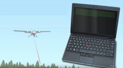
What is LiDAR Drone Technology (UAVs)?

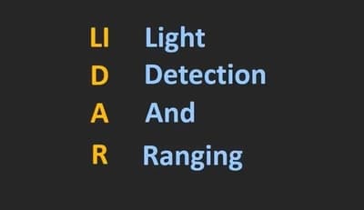
So what is LiDAR Technology ? LiDAR or Light Detection and Ranging is method that uses lasers to measure the elevaiton of things like the ground, forests and even buildings. LiDAR uses ultraviolet visible or near-infrared source to sense objects. Pulse is a name for a light energy that is emitted by LiDAR system. Light reflected from ground or object is known as return. The principle of LiDAR system is that he sends a pulse in the form of light and it waits for that pulse to return. It measures how long it takes for the emitted pulse to return back to the sensor. It’s a lot like sonar which uses sound waves to map things, radar uses radio waves to map things but a LiDAR system uses light sent out from a laser.
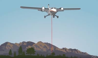
A LiDAR unit scans the ground from side to side as the plane flies, because of this it covers a larger area. Drones and helicopters are most commonly used for LiDar technology and detection on a certain broad areas. These are the types of LiDAR technologies that exist; Topographic maps are most commonly used in less illuminated areas. Metric LiDAR uses water penetrating green light to measure seafloor and river bed elevations. Terrestrial LiDAR for mapping buildings, natural features and trees at ground level.
How Does LiDAR Works?
1. LiDAR Sensors – Scans the Ground
You need to know that LiDAR technology contains laser beams that scan the very surface of the earth. That sensor has a detector in it so that it receives feedback. The laser system uses either green or near infrared light, because these wavelenghts or types of light reflect strongly off of vegetation.
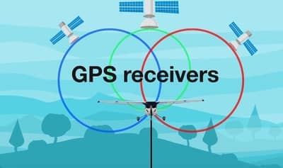
2. Global Positioning System (GPS)
Another very important feature of LiDAR technology is the GPS system, which measures altitude using x, y, z coordinates. These variables are important in attaining accurate elevation values. The GPS allows us to figure out where LiDAR reflections are on the ground.
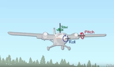
3. Inertial Measurement Unit (IMU)
The third component of the LiDAR system is what’s called an inertial measurement unit or IMU. The IMU tracks the orientation and speed of the plane in the sky as it flies, which is important for accurate elevation calculations.
4. Computer – Records Data
Finaly, the LiDAR system includes a computer. The computer records all that important height information that the LiDAR collects as it scans the earth’s surface. No compute – no data. It’s as simple as that.
Let’s now see how all these components work together and give us useful information? What LiDAR technology is doing is scanning the earth using its system to transmit light to it. This moves the light pulses towards the earth and measures the time it takes for that same light to return to the LiDAR system itself. To get height the LiDAR system records the time that it takes for the light energy to travel to the ground and back. The system then uses the speed of light to calculate the distance between the top of that object and the plane. Airborne system scans the earth from side to side to cover a larger area on the ground when flying. So while some light pulses travel vertically from the plane to the ground or directly at nadir, most pulses leave the plane angle. If you want to know more about this technology, my recommendation is: LiDAR Technologies and Systems which you can find on Amazon.
Top 5 Uses of LiDAR

Autonomous vehicles If you’ve seen a self-driving car before, you’ve probably seen a LiDAR sensor. It works as an AI of autonomous vehicles. It is like your human eyes have the ability to look in every single direction all of the time, and by that you can know the precise distance of all objects that are in relation to you. LiDAR enables a self-driving car to view the surroundings with a few special superpowers.
Agriculture. LiDAR can be used to create 3D elevation maps of a particular land which can be converted to create slope and sunlight exposure area map. This information can be used to identify the areas which require more water or fertilizer and will help farmers to save on their cost of labour, time and money.
River Survey. What LiDAR technology can tell us when it comes to rivers is their depth, width and flow.. It helps and monitoring the floodplains.
Modelling of the Pollution. LiDAR uses a special infrared wavelength link.. This helps to image the particulate matter which are in the same size or larger than the wavelength. So LiDAR can detect pollutant particles of carbon dioxide, sulfur dioxide and methane, and this helps to create a better planning of the city.
Archeology and Building Construction. LiDAR plays an important part for the archaeologists to understand the surface. LiDAR can detect micro topography that is hidden by vegetation which helps archaeologists to understand the surface. Ground based LiDAR technology can be used to capture the building’s structure. This digital information can be used for 3D mapping on the ground which can be used to create models of the structure.
LiDAR vs RADAR
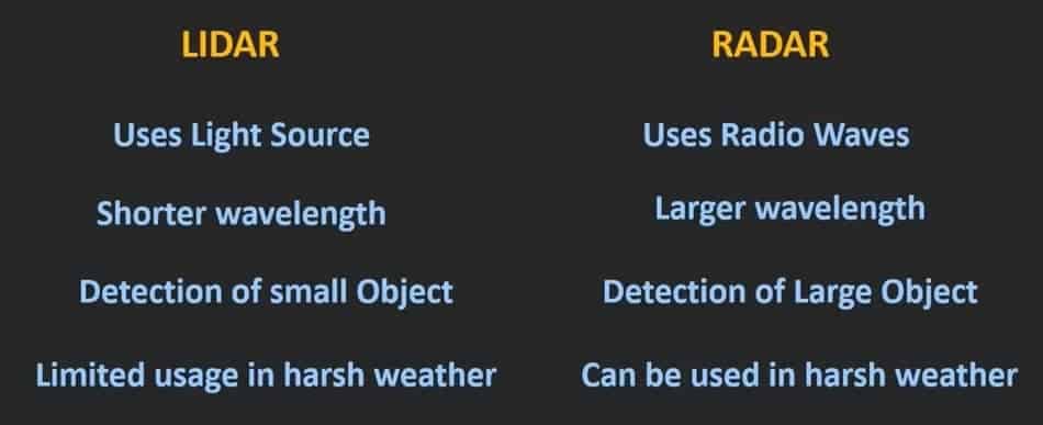
Now that we know how LiDAR system works, let’s look at the difference between LiDAR vs RADAR. So let’s exactly understand what is the difference between this LiDAR system and the radar system. Radar = Radio Detection & Ranging. So, instead of light waves, in case of the radar system, the radio waves are used for the measurement. The differences we can cite are that radio waves cannot detect small objects, and light waves can detect even the smallest objects.. While using the light waves, we can even detective very small objects. So using the LiDAR system, we can achieve the much more precision. Because of its precision, these LiDAR systems are used for the 3D mapping of the object or even for the surface scanning of the object. While radar systems are used in applications where the exit size and shape of the object is not important, but the detection distance is more important. So they are used in military applications or in air traffic control, where the detection of the object is more important rather than the size and shape of the object, or even they are used in some range finding applications. The advantage of Radar over LiDAR is that it works even in the harsh environment like in case of the rain, fog or even snow, while the LiDAR system cannot work in such harsh environment.
Discoveries Made with LiDAR System
LIDAR technology is changing the world of archaeology. From Angkor in Cambodia to the lost Maya cities in Guatemala, here are just a few amazing things that researchers have found with this Light Detection technology called LiDAR. World of archaeology is in revolutionzing age where we can use LiDAR technology for surveying landscapes. This technology can be used anywhere, which is why it is so popular. These are the most famous breakthroughs discovered by this technology:
1. Angkor, Cambodia
You probably heard of sprawling Angkor complex in Cambodia. Angkor Wat is regarded as one of the largest structures in the World. What the LiDAR managed to revealed is ancient temples and boulevards, which has shown us how little we actually know about this medieval Empire.

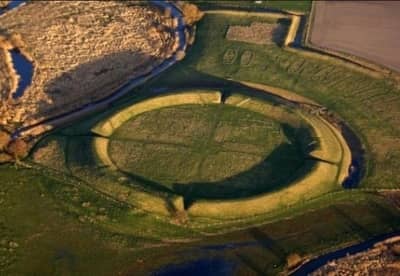
2. Borgring, Denmark
In August 2017 LiDAR technology has revealed a very interesting circle shaped fortress in eastern Denmark. This fortress was discovered in 1930. This fortress has a diameter of 144 meters. It also shows that the fortress could be more than 900 years old. With that we can get a better perspective on how the vikings may lived during that historic time. When we look at what was discovered through LiDAR technology, we can expect many more such discoveries in the near future.
3. Tikal, Guatemala
Another major breakthrough that made possible by LiDAR technology in the big jungle is Maja. The whole World was left surprised when scientists were able to find this lost city, although for decades, scientists had been searching for and remaining empty handed. Also, this area has been mapped over 2,500 square kilometers, which is considered to be the largest data set ever used for this type of research. The Maya empire was extremely sophisticated and advanced and the size was almost equal to medieval England.