What is Drone Mapping?

The drone industry is growing at an incredible pace and the technology provided by the drones is limitless. UAVs are now used in a large range of commercial applications, whether it’s television filming, real estates, package delivery, weddings or 3D mapping. And one of these applications which is very profitable is Drone Mapping. But what exactly is drone mapping? Simply put, Drone Mapping is when you specify the area that you like to map and the drone flies around that area and makes a 3D map out of it, and this technique is called Photogrammetry. If you’re professional you can make it so useful for things like surveying property, checking on your crops if you’re a farmer, or simply charge the service to someone that need a 3D map.
One of the purpose of using drone mapping is way of providing mapping services to clients. In the last couple of years since FAA passed the law and allowed the use of UAVs, many people turned on to provide these mapping services. Another thing you need to know is that the FAA and federal law require the UAV pilot to be certified. A lot of people become FAA-certified remote pilots, flying UAVs and providing mapping services. So let’s explain some basic things you need to know about drone mapping.
Photogrammetry
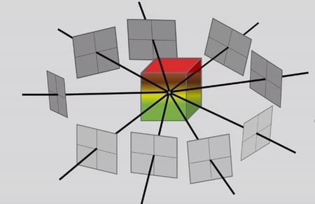
Photogrammetry can be defined as the science that is measured from photographs, usually those taken from the air. When we talk about photogrammetry, its input is photography, and its end point is a map or some kind of 3D model of an object.. If you didn’t know more than 90% of today maps that we use were made using photogrammetry and we use that maps today. With photogrammetry you can capture 2D and 3D fields with high-speed imaging. Mapping with drones is very similar to this, the main difference being the low altitude a drone can fly and capture higher quality images.
Through photogrammetry we can track all changes that occur on earth, including the direction of flight of birds, the movement of fish from the sea, and other movement processes. What is very important in photogrammetry is that the algorithms that are used here are trying to minimize the sum of the squares of errors. Here we usewell-known method by Levenberg-Marquardt algorithm to minimizate as bundle adjustment. We have 2 types of photogrammetry: Aerial and Terrestrial (close-range) Photogrammetry.
2 Types of Photogrammetry
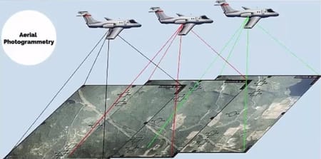
Aerial Photogrammetry
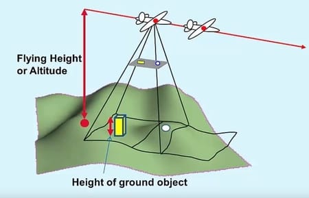
When we talk about Aerial Photogrammetry, we need to know that this is an aircraft with a ground-facing camera. When aircraft flies along the flighing path the multiple overlapping photos are taken from the ground. Previously, classic aircrafts were used to get an accurate picture, but today drones come into play that automatically do the job. They use special technology that allows scanning of the surface under which it passes, and now it’s automated and processes the data itself.
Terrestrial and Close-range Photogrammetry
When we talk about Close-range Photogrammetry we must understand that camera is located on the ground and it is fixed. This type of photogrammetry is can be useful for measuring buildings, mines, earth-works, stock-piles, etc. Also very familliar name for this photogrammetry is also called Image-based modeling.
The Industrys for Drone Mapping
Land Surveying
Job of land surveyors is the measurement of a piece of land so they can precisely determine boundaries of some land. With this particular data stored, they create maps and documentation. Photogrammetry of drones can be very useful for this part of the profession as maps are an integral part of this profession. What they can do is to get a highly accurate plan with 3D topographic map, for what was previously very difficult to do.
Real Estate
It’s probably the most popular amongst everybody because it’s so easy to get into by talking to some Realtors. The answer to this question can very easily be solved by drone mapping. So if you have editing skills it’s really in your best interest to go ahead and use those editing skills to make a little bit extra money with editing. DroneDeploy (which I have mentioned and described in the text below) is considered a very high quality application to use.
Inspection
Inspections are a little bit harder to get into. Number one, you really should have a good clear camera in order to do this, even though it’s not necessary but you should probably have it. What can be accomplished with this is a thorough description of the roof, while IR sensors allow to detect the isolation of poorly isolated areas.
Agriculture
If we had to choose, we can say with certainty that one of the largest drone mapping industries is agriculture. What this does is that farmers have the more power to analyze their crops with drone mapping technology, which means they can save a lot of time and increase crop yield. Many large companies are involved in agriculture and one of the most well-known applications currently used is Field Scanner.
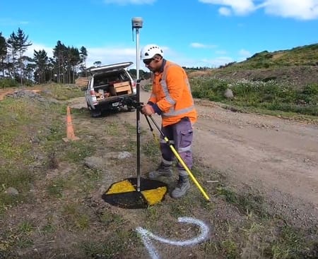
Ground Control Points (GCP)
So let’s talk about exactly what ground control points are? I think anyone who is involved in this type of business has heard about GCP’s. Ground Control Point is just a single GPS coordinate. GCPs are marked targets that are strategically put spread throughout the area of interest. It should be noted that when it comes to drone mapping, each of these projects is different from each other and does not need a high level of global accuracy. When you work with GPS your reference coordinate system is called wgs84 (which stands for world geodetic system 1984). Depending on the needs of your clients the wgs84 date may need to be converted into another date.
Meaning of Point Cloud in Drone Mapping
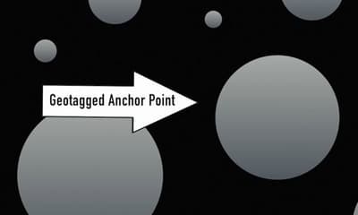
If you have a drone mapping business, you need to know what a point cloud is, so you don’t sound like an idiot in front of the client. What is interesting in this is that you need just compare the new technology and the old one and learn how to make the best of it moving forward. Picture that is taken from a drone is made up of millions of pixel points. Every point carries data with longitude, latitude and altitude coordinates. Basically that means a geotag is assigned to a pixel. We call that pixel Anchor Point, and all the pixels around the Anchor Point will then be assigned a GPS location based off of their relative proximity to the Anchor Point. And because the points are relatively accurate, you need RTK GPS to give you a precise point.
Drone Mapping Softwares
The demand for high quality aerial data capture from drones or UAVs is growing fast and now professional standard drones are readily available at affordable prices. The software easily enables us to put together a comprehensive survey of land, buildings and infrastructure and presents it in a variety of easy to manage formats. The best feature is the ability to take accurate measurements of length, area and volume straight from the maps. Today, by using the latest drone mapping software and a little practice, high-quality aerial maps can be created by any competent drone pilot, which allows most people to join this business. There are a lot of mapping software’s on the market today. Over the last few years, a lot of potential has been showing in this drone mapping industry and an increasing number of them are getting involved in the fight for this market, so new programs are coming from time to time. These are the 3 biggest players in Drone Mapping software industry for now: 1. Pix4D, 2. Agisoft, 3. DroneDeploy.
CONCLUSION
We got a clear and detailed answer to what is drone mapping. The great thing about Drone mapping is the very high-resolution imagery and the relative simplicity of processing the imagery into surface models and orthophotos. When we talk about the weaknesses in drone mapping, then it is the difficulty checking the accuracy of the surface model and digitizing the planimetric features, which sometimes can be a problem. Drone mapping has huge potential for a number of sectors including construction, agriculture, mining, infrastructure inspection and real estate. When we talk about new technologies, it is a good idea to look for more creative ways to adopt it. We have to know and become familiar with the good and the bad sides of it. What is interesting in this is that you need just compare the new technology and the old one and learn how to make the best of it moving forward. This is a very profitable business and has plenty of potential which you can use.